
-
 Telomere
-
 Reunion marsh harrier
-
 Crystal chemistry
-
Stalagmite
-
 Dehiscence
-
AFSSA
-
 Tropopause
-
Angioplasty
-
Endemic
-
 Banya
Banya
-
 Mirabelle plum
-
 Apollo 1
-
Clay stone
-
 ECC
ECC
-
 Adenine
-
Acutance
-
 Climax community
-
 Time-lapse
-
 Gasification
-
 Dipole moment
-
Translocation
-
Stratified
-
Oligocene
-
 Coverts
-
 Reducing agent
-
 LHC
LHC
-
Differentiation
-
 CHN
CHN
-
Dysentery
-
 Graphics software

Map projection
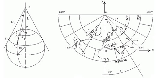
A map projection is the result of applying mathematical formulas relating spherical coordinates in a system of geographic coordinates, to plane coordinates. These formulas transform a representation of the earth on a rotating ellipsoid into a flat representation, a map.
Below, the LAMBERT conformal conic projection. A cone is placed tangentially to the sphere. The 3D points on the sphere are projected on to the cone, then the cone is opened out giving a map with 2D points (and altitude information).
Latest
Fill out my online form.